
Explore marine objects
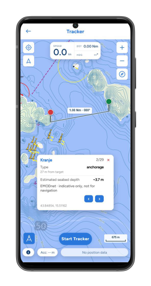
Inspect supported objects on the map and use the optional Seamarks overlay for additional context around harbours and waterways.
Record a quiet coastal cruise, revisit a favourite passage or learn from a training session. SailAlign brings your sailing maps, GPS tracks, route replay and performance analysis together in one app.


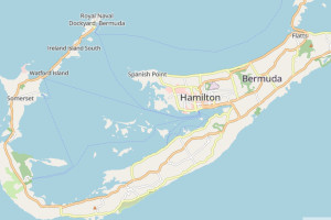
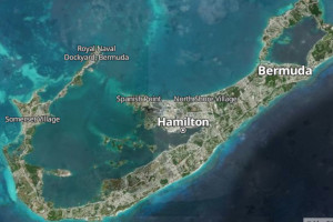
Choose a clear everyday map, a satellite view of the coastline or an ocean-focused style. In the app, open Settings → Map style to change the background.
All available styles are Default, Satellite, Outdoor, Ocean, Streets, Base, Black and white, Winter, Topographic, Landscape and Bright. Choose the view that helps you read your surroundings and your recorded route.
Switch the Seamarks layer on separately to add community-sourced marine objects.
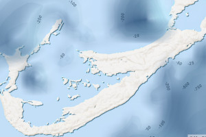
Inspect supported objects on the map and use the optional Seamarks overlay for additional context around harbours and waterways.
Display depth contours and inspect estimated depth from the available bathymetry data. Coverage and resolution vary by location.
Use the map measurement tools to check distance and bearing between positions, then relate them to your passage or recorded track.
Start a GPS track and follow speed, distance, duration and the route on your sailing map. Save the trip to your digital logbook so the journey stays connected to your sailing records.
Recording can continue with the screen locked or while using another app. Grant the requested location permissions, including background access where required, and allow location services and background activity on your phone.
GPS recording and mobile data are separate. Recorded points are stored on the device and queued for upload when connectivity is available, so a patchy connection does not need to end your track. Accepted uploaded positions are stored on the server for later retrieval.
SailAlign keeps saved points and recording state for recovery after an interruption. If the battery runs out, already saved points can be recovered; the phone cannot record further positions while switched off.
Background access depends on your device and operating system. Review power-saving settings before a long trip, keep enough storage available and check that recording has started. Local storage and recovery improve resilience; they are not an unconditional guarantee against every device or storage failure.
While connected, select the area you want to save and download it with your chosen map style. Check the saved area and style before departure; outside that area, map detail may still need a connection.
The app manages an active saved area. Replacing or refreshing it needs connectivity and sufficient free storage. Map downloading pauses during active tracking, so prepare the area before you start recording.
Three separate things: an offline map supplies the saved background; offline GPS recording stores new positions; opening a complete previously saved route for replay or analysis may first require downloading its route data. Plan for each before leaving coverage.
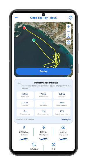
Return to the route from your logbook and follow your position through the trip. Scrub the timeline, change playback speed and use the speed and course graphs to find the moment you want to inspect.
Follow your way into a bay, see where the pace changed or share the story of a day afloat with your crew.
Move between the timeline and map to connect a change in speed with the position and course at that moment.
After performance analysis, select detected manoeuvre markers on the replay map or timeline to inspect significant course changes in context.
Run analysis on a complete recorded track when you want more detail. SailAlign processes the downloaded route on your device and caches the result, bringing practical speed and course-change metrics into the same workflow as replay.
For a cruiser, it is a way to understand the pace of a passage. For a racing crew, it can support a debrief about sustained speed, turns and the time needed to settle back into a rhythm.
| Metric | What it helps you understand |
|---|---|
| Median moving speed | A useful picture of your typical speed while moving, with less influence from isolated high readings. |
| 90th percentile speed | The faster end of your recorded sailing pace, beyond a single instantaneous peak. |
| Best 30-second speed | Your strongest short sustained burst, useful for reviewing a brief fast section. |
| Best 5-minute speed | A longer sustained average that can help compare steady sections of a session. |
| Significant course changes | Detected manoeuvres that you can inspect on the map and timeline. |
| Estimated speed loss and recovery | How much speed fell around a detected manoeuvre and how long recovery took, where the data supports a reliable estimate. |
Place red and green measurement pins to read their distance and the true bearing from red to green. Drag each pin independently, or attach a pin to your displayed boat position so it follows you. An adaptive scale shows metres or nautical miles as you zoom. The divider is also available on course editor and RC maps in the app and desktop dashboard.
Save routes and map snapshots to your Logbook. Use on-device performance analysis with a memory-conscious background worker when you want to inspect the recorded session.
Select the map style, grant location permissions and download your offline area if needed.
Begin the track before departure and check that speed, position and elapsed time are updating.
Finish recording and keep the trip with its route and sailing record. Let any queued data upload when connected.
Open the saved route, explore the timeline and run performance analysis when you want a closer look.
Use GPX import to bring an existing sailing track into SailAlign. Use GPX export to save a track for compatible mapping and analysis tools. Keep a digital record of the trip in the sailing logbook and connect boat usage with maintenance planning.
Organising races too? Explore regatta management and live fleet tracking, or see the complete all-in-one sailing app.
Yes. SailAlign supports background GPS recording with the required location permissions. Keep location services enabled and allow background activity; operating-system restrictions and battery settings can affect recording.
Recorded points are stored locally and queued for upload when a connection is available. Recovery uses saved recording state and points. Points already saved can be recovered after interruption, but a switched-off phone cannot record new points. Storage, permissions and device conditions still matter.
Download the area and map style you need before departure. The saved map area can be viewed without a connection. Offline GPS recording is separate from offline maps; downloading a complete saved route for replay or analysis may require connectivity.
Open Settings → Map style to choose Default, Satellite, Outdoor, Ocean, Streets, Base, Black and white, Winter, Topographic, Landscape or Bright. Seamarks can be switched on separately.
Analysis detects significant course changes and estimates speed loss and recovery around those manoeuvres. Without wind data, it does not classify every turn as a tack or gybe. GPS quality, sampling gaps and track length affect the results.
Yes. SailAlign supports GPX import and export so you can bring in a sailing track or save a route for use in compatible tools.
No. Record a coastal cruise, keep a route with your logbook and replay a day on the water. Performance analysis adds useful detail for training and racing when you want to compare speed and manoeuvres.
Bring the next part of your sailing workflow into the same app.
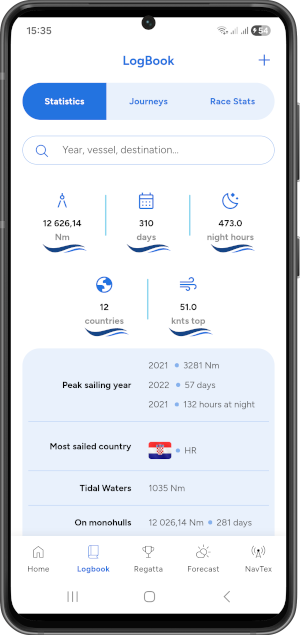
Bring voyages, boats, crew records and onboard preparation into one place.
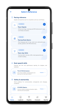
Review racing, safety and seamanship with clear illustrated lessons.
Set the perfect start, track your races, and stay prepared with one powerful app made for sailors - download SailAlign and experience the difference.